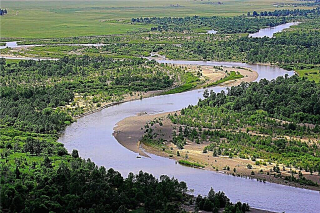
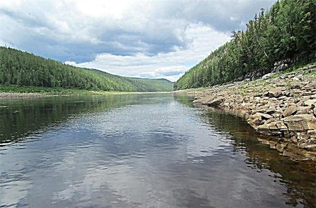
Irkutsk region is famous for its natural beauty, first of all, for Lake Baikal. But apart from it, there are enough water resources in the region, including rivers. They are often characterized by fast currents, as many are of the mountain type, abundant in fish and suitable for tourist recreation. The abundance of rapids creates the basis for organizing rafting routes. The best time to visit is from late spring to early autumn. The rest of the time the rivers are covered with ice.
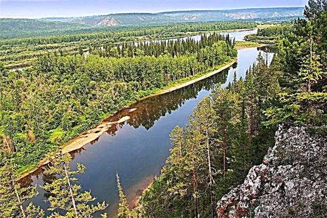
Lena occupies a special place in the list of rivers in the Irkutsk region: it is an important transport artery. Reservoirs have been built on some rivers, including the Angara. They are used for domestic and industrial needs. Relatively small rivers like Agul also have their own charm. In their valleys, there is always something to do during the high season.
The longest rivers of the Irkutsk region
List of the largest rivers flowing through the region.
Lena
The name is translated from Yakut as "big river". The largest of the Russian rivers, whose basin is entirely within the borders of the country. It flows through Yakutia and the Irkutsk region. It flows into the Laptev Sea. Lena is an important transport artery. Large ports have been built on it, including in Yakutsk. Auto and railway bridges have been thrown across the channel. In the middle course, the natural park "Lena Pillars" was founded, included in the UNESCO World Heritage List.
The total length of the river is 4400 km.

Lower Tunguska
Also applies to the Krasnoyarsk Territory. The right tributary of the Yenisei originates on the Central Siberian plateau. In mid-autumn, a stable ice cover forms on the surface of the water in less than two weeks. When the river breaks open in May, ice jams form. During floods, the Lower Tunguska becomes navigable for one third of its length. The city of Turukhansk was founded at the mouth.
The total length of the river is 2,989 km.

Podkamennaya Tunguska
Sometimes separate names are used for its upper reaches - Katanga and Chulakan. The channel runs through the territory of the Irkutsk region and the Krasnoyarsk Territory. Most of the rifts are found on that part of the Podkamennaya Tunguska, which belongs to the Central Siberian Biosphere Reserve. In high water, 1,150 kilometers of the river is accessible for navigation by boats with shallow draft.
The total length of the river is 1865 km.
Vitim
The right tributary of the Lena passes through four regions: Trans-Baikal Territory, Buryatia, Irkutsk Region and Yakutia. The river is navigable for almost a third of its length. The only city on the coast is Bodaibo. Stone Age sites have been found nearby. Three bridges have been thrown across the riverbed. A route for the rafting of water tourists has been laid. The most difficult obstacles are the Paramsky and Delyun-Oronsky rapids.
The total length of the river is 1837 km.

Angara
The city of Irkutsk is located on the river bank. The only river flowing from Lake Baikal. Also applies to the territory of the Krasnoyarsk Territory. The first pontoon bridge across the Angara was built in 1891. The Shaman-stone is located not far from the source. Ust-Ilimsk has another natural attraction - rock complexes, for example, "Three Sisters". There is a cascade of reservoirs on the riverbed.
The length of the river is 1779 km, in the Irkutsk region - 1360 km.

Uda (tributary of the Taseeva)
An alternative name is Chuna. The Taseeva tributary, also territorially related to the Krasnoyarsk Territory. It flows out of the ridge and merges with Turquoise. It freezes in the middle of autumn, completely breaks open from ice only in May. Uda is used for regional shipping and timber rafting. There are fishing spots. The largest city on the coast is Nizhneudinsk.
The total length of the river is 1203 km.

Turquoise
The river of the Krasnoyarsk Territory and the Irkutsk Region. It merges with the Chuna and forms the Taseeva River. There are about 300 lakes in the basin. The upper course is mountainous and rapids. In the lower reaches, the channel begins to diverge into bends. Its third is used for timber rafting. Traditionally, in the past, Old Believers settled in the lower reaches. The largest settlements are Taishet and Biryusinsk.
The total length of the river is 1012 km.

Chara (tributary of the Olekma)
The left tributary of the Olekma belongs to the Trans-Baikal Territory, Irkutsk Oblast and Yakutia. The translation of the name from the Evenk language is “shoal”. The Ruy is navigable from its tributary to the mouth. The main rafting route on it has the IV category of difficulty. Several villages are founded on the coast, including Bolshoye Leprindo and Bes-Kyul. Several deposits of gold, coal and ore are being developed in the Chara basin.
The total length of the river is 851 km.

Chona
Refers to the territory of Yakutia and the Irkutsk region. It flows into the Vilyui reservoir, is included in the Lena basin. In the upper reaches of the channel, there are rapids, waterfalls, bedrock outcrops. In the valley, there have been preserved oxbows. There are practically no fish, and the workers' settlements, founded in the last century on the coast, do not have a permanent population. The largest tributary is the Vakunayka.
The total length of the river is 802 km.

Kirenga
The channel runs through three districts of the Irkutsk region. It is formed at the confluence of two rivers: the Left Kirenga and the Right Kirenga, and flows into the Lena. In the upper reaches it has a mountainous character, in the lower reaches the current slows down. In the middle reaches, it comes close to the Baikal-Amur Mainline. Fishing is varied: almost two dozen species of fish are found in the waters of the river. There are many villages and workers' settlements along the coast.
The length of the river is 669 km.
Nepa
It flows through the Katangsky region. It begins on the Angarsk ridge and flows into the Lower Tunguska. The river basin lies in a continuous permafrost zone. Taiga vegetation predominates on the coast. Most of Nepa is navigable. Rafting and sport fishing competitions are organized. Not far from the river bed there is a developed agate deposit.
The length of the river is 683 km.

Oka (tributary of the Angara)
It originates in Lake Okinskoye in Buryatia and flows into the Bratsk reservoir in the Irkutsk region. It is navigable in the lower reaches, practically along the entire channel it is used by water tourists for rafting. There are many small settlements in the Oka basin. Autopsy from ice occurs in mid to late summer. Summer floods lead to flooding of the area, but they traditionally do not threaten local residents.
The total length of the river is 630 km.

Ilim (tributary of the Angara)
The right tributary of the Angara, whose name is translated from Yakut as "fishing net". The river is navigable, it is used for water tourism, as well as for water supply to settlements in the area. During the construction of the Ust-Ilimsk reservoir, the most significant threshold of the Ilim was flooded. The fastest current in the upper reaches. There are several important tributaries including the Kochenga and Chora.
The length of the river is 589 km.

Big Pathom
The source is located in the Patomsky Upland, and the river flows into the Lena on the right side. Autumn ice drift lasts three weeks, and a stable ice cover is formed by the end of October. 250 kilometers of the total length of Bolshoi Patom are used for shipping in high-flowing periods, as well as for timber rafting. Porous areas are included in the rafting route of the IV degree of difficulty.
The length of the river is 570 km.

Chuya (tributary of the Lena)
The right tributary of the Lena, also related to the lands of Buryatia. The source is located on the Synnyr ridge. The name is based on the common hydronym "chu", synonymous with the word "river". There is only one working village on the coast - Gorno-Chuisky. There is also only one significant inflow - Malaya Chuya. In the last century, minerals were mined in the upper reaches. The most common fish are dace, whitefish, grayling.
The total length of the river is 512 km.

Irkut
The left tributary of the Angara also flows through Buryatia. The source is the mountain lake Ilchir, the mouth is the center of Irkutsk. The river is floatable, and the longest tourist route along it is 120 km. A favorable period for tourism is from May to October. There are beaches, mushroom and berry places on the shores.Irkut also attracts fishermen. There are no problems with logistics: more than 20 settlements are located along the riverbed.
The total length of the river is 488 km.

Tetere
The source is in the Krasnoyarsk Territory, and the mouth is in the Irkutsk Region. The river bed is rapids and widens considerably in the middle course, bends and meanders appear. May is the most abundant month. The Tetere floods are not terrible: the banks have no settlements. Fishing places attract fans to sit with a fishing rod on the shore. Perch, grayling, taimen and pike peck here.
The total length of the river is 486 km.

And I
Formed at the confluence of the Kholba and Khiai rivers. It flows into the Bratsk reservoir. In the past it was a tributary of the Angara. The channel is straight and wide-floodplain. It has many tributaries, the most significant are Ikei and Kirei. The largest settlement on Iya is the city of Tulun. The summer months are full of water, and at the same time the most tourists come to the valley. Most of them are for fishing.
The length of the river is 484 km.

Kova (tributary of the Angara)
The river of the Krasnoyarsk Territory and the Irkutsk Region. It flows into the Boguchanskoye reservoir, built on the Angara. A very heterogeneous river: the alternation of stretches and rapids runs along the entire channel. There are mud springs on the Deshembinskoye lake. In Soviet times, a sanatorium was built on its bank. Sports and amateur rafting is organized on Kov during the summer season.
The total length of the river is 452 km.

Bolshaya Erema
The source is the confluence of the Right and the Left Erema, flows into the Lena. Refers to the territory not only of the Irkutsk region, but also to the Krasnoyarsk Territory. Only some sections are suitable for rafting and comfortable boat travel. In the upper reaches, the channel is more meandering, while the lower and middle reaches are characterized by a large channel width. There are no settlements along the coast. Pike and ide are found in Bolshoi Yerem.
The total length of the river is 411 km.

Kuta (tributary of the Lena)
The tributary of the Lena, referring to the central part of the region. The translation of the name is "wetland" or "bog". The valley is covered with forests, there are many swamps in the upper reaches. The Kuta estuary is rich in mineral springs. Water and mud from here are used for procedures in the nearby Ust-Kut sanatorium. A small delta has also formed here, which is actively used for recreational recreation.
The length of the river is 408 km.
Mum
Left tributary of the Vitima. The toponym is based on the Evenk word “moma”, translated as “populated place”. The river originates on the northern slopes of the Verkhneangarsky ridge. The channel is branched and meandering. A tourist route has been laid along it, including a section with small waterfalls and rapids. In the last century, mica deposits were developed in the Mama basin, which have now dried up.
The length of the river is 211 km.

Eika
The source is a small lake at the junction of the Krasnoyarsk Territory, Yakutia and the Irkutsk Region. The name comes from the Evenk language and means "polynya". The channel is winding, there are no settlements along it. The river basin is characterized by a large number of lakes: there are about 600 of them, but some are temporarily drying up. Eika is used for rafting, recreation, fishing.
The total length of the river is 400 km.

Kazyr
The translation of the name of the river from Tuvan is “evil” or “fierce”. Sometimes he uses another name - Bolo. In the upper reaches, the river has a mountainous character, there are waterfalls and rapids on it. Hence the opportunity for kayaking, catamarans and inflatable rafts. In the lower reaches, for 97 kilometers, Kazyr is navigated during floods. Grayling and lenok peck well here.
The total length of the river is 388 km.

Floodplain (tributary of the Biryusa)
The right tributary of the Biryusa flows into it near the village of Mirny. It flows practically along the border of the Irkutsk region and the Krasnoyarsk Territory. It originates in the northern spurs of the Eastern Sayan. The water in the Poima is muddy for most of the year, which should be taken into account when planning leisure activities, including fishing. There are a lot of fish in the places where the streams flow. Main species: dace, pike, perch, burbot, grayling.
The total length of the river is 382 km.

Vacunayka
The river belongs to the Lena basin and flows in two regions: the Irkutsk region and Yakutia. There are no settlements on the coast, the vegetation is mainly deciduous and medium taiga. The channel is not uniform: straight sections are interspersed with large bends. Vacunayka is suitable for rafting tourism. Sturgeon and salmon species of fish enter the river for spawning. The Chonsky resource reserve is located nearby.
The total length of the river is 362 km.
Tea (tributary of the Lena)
It originates on the slopes of the Verkhneangarsky ridge in Buryatia. It is the right tributary of the Lena. Brega is covered with deciduous forest with an admixture of coniferous species. There are few inhabitants in the valley, part of the territory is swampy. In the lower reaches of the fishing area, it is possible to travel by boat. Rafting routes for kayaks and inflatable rafts are divided into several categories of difficulty.
The total length of the river is 353 km.

Agul
The right tributary of the Kan River, which also flows in the Krasnoyarsk Territory. The upper reaches are gorges and picturesque valleys. The flow at the mouth slows down as much as possible. Passes through Lake Agul and the Tofalar nature reserve. Rapids, rapids and rifts are found in different parts of the channel. Therefore, rafting is a popular type of tourist recreation on Agul. The water level is at its maximum at the junction of spring and summer.
The total length of the river is 347 km.

Chewing
It is completely located within the Bodaibo district of the Irkutsk region. It has more than 40 tributaries, but most of them are streams or minor rivers. It is navigable downstream of the Khomolkho tributary. Snow and rainfall influences the seasonal water level. The channel runs through Lake Tolendo. Freezing takes about 200 days. Gold mining enterprises operate in the Ruyi basin.
The length of the river is 337 km.

Molbo
The river of the Patomsky Upland of the Irkutsk Region and Yakutia. On the left side, it flows into the Chara 165 kilometers from its mouth. Molbo is covered with ice in the middle of autumn, breaks open in May, and then a long flood begins. In terms of tourism, it is little used. Mainly of interest for local fishing. There are no beaches, the shores are mostly rocky and covered with forest.
The total length of the river is 334 km.