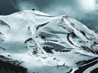
The waterways of Karelia are fed by underground and surface tributaries. There are 27 thousand rivers in the Republic, many of which are related to the Baltic Sea. Rare rivers of Karelia flow into the Caspian, some flow to the waters of the White Sea. There are waterways in the republic that cross the border with Finland, which have a completely different name there.
In total, the total length of the Karelian rivers is 83 thousand km. The average flow velocity of waterways varies in the range from 0.1 to 6 m / s. Rapids and waterfalls are common for Karelian rivers. It is the rivers that make the nature of Karelia rich and beautiful. They feed forests, meadows and hillsides with their waters, providing food and water to all living things around. An extensive tourist network is developed in these areas. There are also hydroelectric power plants in the Kemsky and Ondsky regions.
The longest rivers in Karelia
List, photo with names and descriptions of the main waterways of the region.
Suna
It flows into Onega. The water area is 7670 km². At the mouth of the river is its pearl - the Kivach waterfall. Suna has many rapids and many waterfalls. There are also navigable sections on the river. Hydroelectric power stations have been built in the fast-flowing areas. Today the river is considered a simple tourist route. Along its water area there are kayaking routes.
The length of the river is 282 km.

Benefit
The water area consists of an upper and a lower part. The lower part reaches the White Sea, the upper part forms Vygozero. The drainage basin covers an area of 27,100 km². The name of the river is translated from Norwegian as "depression". At the mouth of this particular river, petroglyphs of Besov Sledki were discovered. The rock carvings there are dated back to the 4th millennium BC. There are no fast sections and large rapids in this area.
The length of the river is 237 km.

Chirko-Kem
Right and northern tributary of the Kem. The pool covers an area of 8270 km². The river is notable for its way of replenishing water. The tributary feeds on rain and snow melt. The channel is filled with large rifts and rapids, so the river is not navigable. The water area is ideal for sports tourism. The depth here in some places does not exceed 3 meters. The water pool is located in the border zone.
The length of the river is 221 km.

Onda
The riverbed flows into the Vygozerskoe reservoir. The total area is 4080 km². The high speed of the water in the channel makes the river attractive both for rafters and for the construction of a hydroelectric power station. The Ondskaya HPP has been standing on the river since 1957. Fishermen also value these waters because they can catch pike, bream and grayling there. Residential settlements are located around this water area. A highway crosses the river in the Kemsky region. The entire waterway is full-flowing, there are few shallow waters in the channel.
The length of the river is 197 km.

Shuya
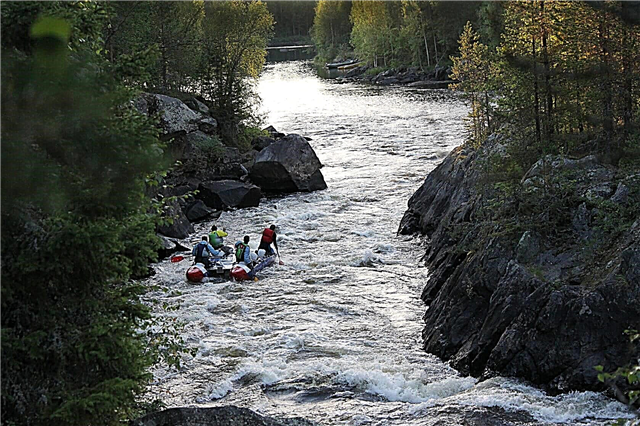
The southern Karelian artery is directly related to Lake Onega. The water area is 10100 km². River waters flow into Logmozero. Numerous salmon spawning grounds are considered a feature of the water area. Rafting competitions are held in areas close to the cities. The waterway has its own hydroelectric power station and is navigable.
The length of the river is 194 km.

Kem
Another northern river of the republic. The Kemi water area occupies 27,700 km². The river bed adjoins the waters of the White Sea. Part of the river flows through Finland. There she is called Pista. The navigable water area is fed by rain and snow waters. A whole cascade of hydroelectric power stations can be found along the course of the water. A feature of the river is the dark water, in which the transparency does not even reach 4 meters. Trout and ide are found among other fish in Kem.
The length of the river is 191 km.

Suma
The water artery flows to the Onega Bay. The drainage basin extends over 2020 km². The relief of the river is represented by stretches and lakes, suitable for rafting and kayaking. Thanks to the coastal forests, the Sumy channel is protected from cold winds. Navigation and sports tourism are well developed on the river. The microclimate around the water area is favorable for early spring and summer holidays.
The length of the river is 164 km.

Kepa
The water area is 1640 km². The Kepa flows into the Kem, making the water area of the second river more full-flowing. It is noteworthy that this river flows past the only settlement with the same name. Grayling, whitefish, dace and trout are the main representatives of the river fauna. The banks of the river are overgrown with forest, where you can pick up a lot of mushrooms and berries during the season. The coastal fauna is represented by hares, roe deer and a variety of native birds.
The length of the river is 154 km.

Vodla
The river flows into Lake Onega. The basin area is approximately 13,720 km². This river has played an important role in history. The Novgorod wars and merchants along the Vodla reached the Northern Dvina. At a considerable distance from the mouth, Padun waterfall is located today. At the moment, some water areas are still navigable. The waterway has rapids with significant differences in altitude, suitable for extreme tourism.
The length of the river is 149 km.

Okhta
As a tributary of the Kem, it extends in the depths of the Karelian taiga. The speed of the water in it is 3-4 km / h. The channel belongs to the lake-river system. The first ice appears here in November, the ice cover breaks up in May. Okhta crosses 15 lakes. Its numerous rapids have long been chosen by tourists. Almost 130 km of the river is occupied by a rafting route. He is one of the most famous in these places. The difference in altitude on the route is 40 meters.
The length of the river is 142 km.

Voloma
The area of the river artery is 2070 km². Voloma flows smoothly into Segozero. The water area intersects with several lakes. The river itself can be described as shallow. The water tourist route begins in the village of the same name. The area around the water area is picturesque. The forests are inhabited by various animals; summer fishing is possible on the Voloma lakes. The ice begins to melt on the river in April.
The length of the river is 138 km.

Tunguda
The river feeds Vyg with its waters. The water area covers an area of 1830 km². Rafting on the river starts near the village of Pertozero. The waterway is endowed with rapids and rifts. The river is home to grayling, trout, pike and perch. Sometimes the channel of the Tunguda forms swampy areas. Mainly coniferous forest grows along the banks. There is no navigation on the river.
The length of the river is 128 km.

Uksunjoki
An artery with an unusual name extends to Lake Ladoga. The river is only 50 meters wide. The relief of the channel is interspersed with swampy areas and few lakes. The channel is crossed by two railways and one motorway. On the right bank of the river there are Finnish border posts, which are empty today. The real border is east of this place.
The length of the river is 121 km.

Deck
The fast river crosses the Pudozh region. The pool covers an area of 1300 km². Once upon a time, timber was floated along this channel. The fauna of the reservoir is represented by a set of fish typical for Karelia. The river is not very popular with tourists, there are places where a person's foot rarely steps. A taiga thicket grows along the banks. In addition to fishing in these lands, the locals are engaged in hunting.
The length of the river is 112 km.

Pista
The source is in Finland. The upstream flows through the border area near the Suoperä point. The estuary includes a system of lakes. The basin area is 3190 km². There are more than 30 significant obstacles on the waterway, and there are no navigable canals. Pista is suitable for rafting and kayaking.
The length of the river is 110 km.

Wonga
Small river. The drop in height in the lower reaches is 70 meters. There are the main rapids suitable for rafting. The upper part of Wonga consists of lakes and backwaters. The river bed is replenished by melting snow and rain. The fauna of the reservoir is standard for Karelia.
The length of the river is 106 km.

Shalitsa
Just 5 km from Vodla, another river flows. The source is in Shalozero. The riverbed is crossed by the A119 road. There are no rapids on the river, the current is slow, the bottom relief is meandering.Along the banks there are settlements such as Shalsky, Novinka, Burlakovo. In the water area there is a set of fish that is usual for Karelia.
The length of the river is 104 km.

Janisjoki
It flows through Finland and Russia. The basin area is 3861 km². The river flows into Lake Ladoga. There are several cascades of hydroelectric power stations along the entire channel. The river area is saturated with rapids. The height differences are significant here, there are areas that turn into fords and shallow water.
The total length of the river is 95 km.

Warrior
On the border with Finland, near Lake Ala, there is the source of the river. The waterway flows into the Upper Kuito. The difference in height along the entire waterway is 129 meters. The Voynitsa area is 1300 km². The village of the same name is the only settlement in the human-accessible area along the river. The Kumi waterfall, where water falls from a height of 14 meters, is considered a landmark of Voynitsy. The river is suitable for boating.
The length of the river is 94 km.

Songo
The waterway flows into Lake Seletskoye. In the upper reaches it is called Tumba. The waterway is fed by snow and rain waters, as well as by the Aryanuks river. The landscapes along the banks of the river are composed of forests and mountain ranges. The river has rapids and is suitable for water sports.
The length of the river is 92 km.

Black
The village of the same name is located at the mouth. The river flows to the White Sea bay. There is a swampy area and impenetrable forests nearby. In summer, the village by the river can only be reached by water, in winter there is no transport connection. Little is known about the river itself.
The length of the river is 88 km.

Colezhma
The beginning of the river is based on the Talskiy Mokh bogs. The area is 788 km². The kolezhma flows into the Onega lip. At the mouth there is a village of the same name, not far from which a railway crosses the river. Local residents of the village are engaged in fishing for navaga on the river. The difference in height along the channel is 140 meters, so Kolezhma is suitable for various types of water sports.
The length of the river is 87 km.

Olonka
A large river in the Olonets region. The river flows westward to Lake Ladoga. The basin of the water area covers an area of 2620 km². Until 1975, timber rafting was carried out along this channel. In Olonka, river pearls are mined for the production of jewelry. Olonets is located at the Megrega tributary. It was on this place that there was once a parking lot of an ancient man several millennia ago.
The length of the river is 87 km.

Pongoma
A large artery of the north of Karelia flows into the White Sea. The source of the river begins at Lake Pongoma. The water area is powered by snow and rain. There are many fish in Pongom: perch, pike, bream and smelt. Today, 3 bridges cross the water area. In some places, there are dilapidated wooden crossings. The basin area is 1220 km².
The length of the river is 86 km.

Shomba
The water artery is a tributary of the Kem. The area is 1090 km². It flows through several lakes. The height difference between the mouth and the source varies in the region of 90 meters. Tourist rafting is carried out along the river. The full-flowing Shomba becomes at the end of May, then through its narrow sections you can swim in kayaks. Shipping on Shomba is not well developed. The source of the waterway begins at Lake Haapajärvi. Shomba is fed by 10 tributaries at once, the water level rises due to rains and melting snows. The name of the river is translated from Finnish as "float".
The length of the river is 85 km.